


RC Flight Assist - F3A training and learing system
 02-25-2016, 02:55 AM
#1
Junior Member
Thread Starter
Join Date: Jan 2016
Posts: 9
Likes: 0
Received 0 Likes
on
0 Posts
Hi!
I would like to present and interest you in a new invention that is a system designed for practicing Pattern Flying skills (it is called: RC Flight Assist or RCFA). In a nutshell the RCFA includes two electronic devices that work together as a radio telemetry system. The idea behing it is to monitor position of the aircraft in real-time and send the data to the pilot's receiver. The Receiver can generate certain tones that clearly indicate if the airplane is in proper position on the sky. According to the tones the pilot can maneuver so to stay in flight area. It would be worthly to mention that the system was tested in cooperation with best Polish F3A pilot how have won 2015 trophy (nonetheless it stays unclear if he did that thanks to practicing with RCFA )
)
The system has also another features which are described on a project's homepage that is: www.littlecircuit.com, where I humbly invite.
One movie can replase thousand words so here it is:
https://www.youtube.com/watch?v=m0nCrscLPIs I'd like to hear from you if it would be interest for you and if you would find it useful and other comments are welcome.
Hope you like it
Best Regards
I would like to present and interest you in a new invention that is a system designed for practicing Pattern Flying skills (it is called: RC Flight Assist or RCFA). In a nutshell the RCFA includes two electronic devices that work together as a radio telemetry system. The idea behing it is to monitor position of the aircraft in real-time and send the data to the pilot's receiver. The Receiver can generate certain tones that clearly indicate if the airplane is in proper position on the sky. According to the tones the pilot can maneuver so to stay in flight area. It would be worthly to mention that the system was tested in cooperation with best Polish F3A pilot how have won 2015 trophy (nonetheless it stays unclear if he did that thanks to practicing with RCFA
)The system has also another features which are described on a project's homepage that is: www.littlecircuit.com, where I humbly invite.
One movie can replase thousand words so here it is:
https://www.youtube.com/watch?v=m0nCrscLPIs I'd like to hear from you if it would be interest for you and if you would find it useful and other comments are welcome.
Hope you like it
Best Regards
 02-25-2016, 08:30 AM
#2

Join Date: Apr 2010
Location: Richmond, CA
Posts: 169
Likes: 0
Received 0 Likes
on
0 Posts
Wow, love it. CRAZY how the flight path is almost always a wandering S!
Been dreaming of this for years but I think the visual aspect shown in the video has been available for some time with GPS loggers but I haven't seen it with the "box" inscribed in the air, and tones are an interesting idea.
Regarding the tones, would be nice if you'd show a video with the sound of the tones. Are you aware of the LFR navigation systems for aircraft in the 1930's-40's? Wonder if your tones are similar. It seems to me that the important thing would be for the audio information should audibly change with the severity of the deviation (as I'm sure you're aware). If the sound is simply on/off, it would be very hard to smoothly adjust course by reference to the sound. In any case, happy to see new tools emerge!
Last edited by n233w; 02-25-2016 at 08:39 AM.
02-25-2016, 10:00 AM
#3
Junior Member
Thread Starter
Join Date: Jan 2016
Posts: 9
Likes: 0
Received 0 Likes
on
0 Posts
Nice to hear you like it - thanks . The tones change accordingly to distance to the Flight Line, of course, so the pilot can smoothly fly into the "Green Zone". The tones were simplified to be not disturbing or annoying but at the same time the pilot knows exactly how far the airplane is from the flight line. There is a headphones port that can be used instead of speaker - it disables speaker and allows to hear tones loud and clear in case of disturbing noises around (like flying drones). There are separate tones to indicate out-of-area or other information (like gps fix lost etc.) - it can be configured though. I wasn't aware of LFR or anything like it. The sound patterns were "composed" by myself from scratch but in cooperation with F3A master pilot so I can say that it works
I will try to record the tones soon.
. The tones change accordingly to distance to the Flight Line, of course, so the pilot can smoothly fly into the "Green Zone". The tones were simplified to be not disturbing or annoying but at the same time the pilot knows exactly how far the airplane is from the flight line. There is a headphones port that can be used instead of speaker - it disables speaker and allows to hear tones loud and clear in case of disturbing noises around (like flying drones). There are separate tones to indicate out-of-area or other information (like gps fix lost etc.) - it can be configured though. I wasn't aware of LFR or anything like it. The sound patterns were "composed" by myself from scratch but in cooperation with F3A master pilot so I can say that it works I will try to record the tones soon.
02-25-2016, 10:16 AM
#4
Junior Member
Thread Starter
Join Date: Jan 2016
Posts: 9
Likes: 0
Received 0 Likes
on
0 Posts
 02-26-2016, 02:10 AM
#6
Junior Member
Thread Starter
Join Date: Jan 2016
Posts: 9
Likes: 0
Received 0 Likes
on
0 Posts
Here you can find a demo Flight Area at Mount Everest that can be oppened in Google Earth:
http://www.littlecircuit.com/download
http://www.littlecircuit.com/download
02-28-2016, 01:34 PM
#8
Junior Member
Thread Starter
Join Date: Jan 2016
Posts: 9
Likes: 0
Received 0 Likes
on
0 Posts
03-14-2016, 04:57 AM
#9
Junior Member
Thread Starter
Join Date: Jan 2016
Posts: 9
Likes: 0
Received 0 Likes
on
0 Posts
Hello,
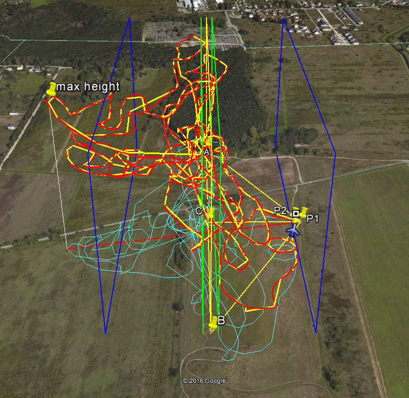
Few changes comes to RCFA. The most important is implementation of the Frequency-hopping spread spectrum (FHSS). This makes using RCFA radio system legal in most countries (including EU, US, Australia/NZ). The preffered frequencies are: 433/868 for UE and 915 for rest of the world.
Here's a demo fly path recorded with RCFA. It includes GPS Logger (red line), Real-time record (yellow line), Flight Area (rectangles). It is a free flight as I'm not a F3A pilot (yet - maybe). It is easy to calculate radio range which was about 450 meters in this case with about 95-99% packets received. Unfortunatelly it was hard to fly further because of lost of sight.
I'll send above kml on demand as a replay to order form at www.littlecircuit.com/order
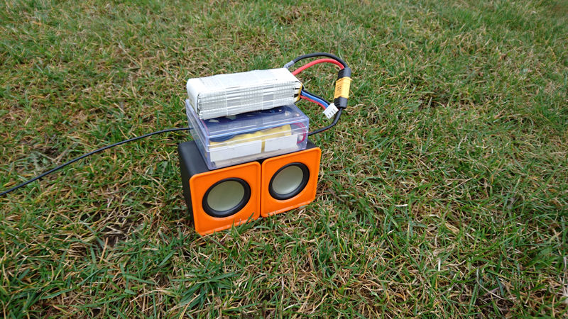
I'm glad that one of RCFA's users has mounted a nice "beeper-station Well done on that
Best Regards
Few changes comes to RCFA. The most important is implementation of the Frequency-hopping spread spectrum (FHSS). This makes using RCFA radio system legal in most countries (including EU, US, Australia/NZ). The preffered frequencies are: 433/868 for UE and 915 for rest of the world.
Here's a demo fly path recorded with RCFA. It includes GPS Logger (red line), Real-time record (yellow line), Flight Area (rectangles). It is a free flight as I'm not a F3A pilot (yet - maybe). It is easy to calculate radio range which was about 450 meters in this case with about 95-99% packets received. Unfortunatelly it was hard to fly further because of lost of sight.
I'll send above kml on demand as a replay to order form at www.littlecircuit.com/order
I'm glad that one of RCFA's users has mounted a nice "beeper-station
Well done on that Best Regards
03-30-2016, 08:16 AM
#10
Member

Join Date: Sep 2003
Location: Linkoping, SWEDEN
Posts: 83
Likes: 0
Received 0 Likes
on
0 Posts
Artyum, congratulations to an interesting project!
A couple of years ago I asked (pleaded) Jeti to develop exactly this feature for their GPS module (to work in combination with the transmitters speech output), but I was told it was too specific for them to be interested in it. I'm glad to see someone else has gotten this idea. I think it is the right way to use GPS information for F3A training. Basically GPS trail is not accurate enough to evaluate the geometry of the flown maneuvers. However, it is good enough to support the pilot with real time information of the aircrafts depth, high etc. I think your product is GREAT, but I think it would be even better if it was developed as a sensor for existing telemetry systems. Make the GPS unit in the plane process GPS data into height, distance relative to "flight plane", angular position in the flight sector, and downlink this data to the transmitter on its own telemetry protocol. Then it's is just to use the transmitters built in telemetry warning functions and speech output to set up the training support.
A couple of years ago I asked (pleaded) Jeti to develop exactly this feature for their GPS module (to work in combination with the transmitters speech output), but I was told it was too specific for them to be interested in it. I'm glad to see someone else has gotten this idea. I think it is the right way to use GPS information for F3A training. Basically GPS trail is not accurate enough to evaluate the geometry of the flown maneuvers. However, it is good enough to support the pilot with real time information of the aircrafts depth, high etc. I think your product is GREAT, but I think it would be even better if it was developed as a sensor for existing telemetry systems. Make the GPS unit in the plane process GPS data into height, distance relative to "flight plane", angular position in the flight sector, and downlink this data to the transmitter on its own telemetry protocol. Then it's is just to use the transmitters built in telemetry warning functions and speech output to set up the training support.
 04-02-2016, 02:57 AM
#12

99% of my practise is done alone plus I am the only F3A flyer in my state, so I thought that it would be very beneficial.
Even for those that do fly with others, I think it would be useful as you still can't tell if you are flying exactly straight. I think it will be extremely helpful for verticals and the top line.
Mine arrived yesterday, so I'm looking forward to trying it out. Might be a few weeks though as I am away at work 'till Wednesday, then go away for a 5 days and then back at work for another week.
Scott
04-04-2016, 12:45 AM
#13
Junior Member
Thread Starter
Join Date: Jan 2016
Posts: 9
Likes: 0
Received 0 Likes
on
0 Posts
The best among the tested modules were u-blox 8, for which the delay was minimal.As for the height indication, only u-blox 8 gaves measuring accuracy of 10-20m. The height given by the other modules was completely unusable. RCFA system is equipped with an altimeter, which indications are incomparably better than any GPS. For those who want to verify GPS altitude accuracy, the build-in altimeter can be disabled.
Another problem is loosing GPS fix during aerobatics when direction of the GPS antenna changes, but this is rather rare situation (1/10 flights). In most cases, the fix is recovered after a few sec during the flight. You have to remember that the GPS signal is strongly dependent on weatcher conditions and available satellites. Sometimes when fix is recovered the position is far from correct a few dozen meters, which is definitely confusing to the pilot, who suddenly hears the sound "outside the area" while the plane can be perfectly in the "line of flight".
These types of problems are natural. They can be reduced but they can not be effectively eliminated.
You were not alone who asked recognized producers to develop this kind of system. I also was thinking of using existing telemetry but came to the same conclusion as Jeti Actually we didn't make tests with multiple persons indication position in the Flight Area. It would be interesting.
05-06-2016, 11:00 PM
#15
Well, I'll answer my own question.
I used it today successfully. I had 5 flights and each flight was recorded onto the SD card. When I got home, I opened each flight and it displayed in Google Earth.
I was in the box most of the time, just a bit far out. Probably around 180 -190 metres.
I used it today successfully. I had 5 flights and each flight was recorded onto the SD card. When I got home, I opened each flight and it displayed in Google Earth.
I was in the box most of the time, just a bit far out. Probably around 180 -190 metres.
05-08-2016, 10:19 AM
#17
Junior Member
Thread Starter
Join Date: Jan 2016
Posts: 9
Likes: 0
Received 0 Likes
on
0 Posts
Hi Scott, I have some email problems. Please post to [email protected].
I'm happy that you manage to run the system. When you fly a bit more with it, could you write some thoughts here on forum. I hope it would be good, but I never can be sure
Somebody could also post some screens of recorded kmls in spare time
Best reagards
Arek
I'm happy that you manage to run the system. When you fly a bit more with it, could you write some thoughts here on forum. I hope it would be good, but I never can be sure
Somebody could also post some screens of recorded kmls in spare time
Best reagards
Arek
