


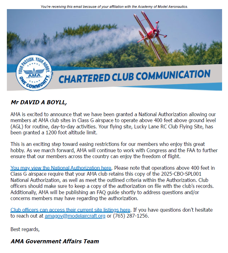
New altitude limits in class G airspace


 04-16-2025 | 11:09 AM
#3
Yep! I seem to remember a certain naysayer saying nay to this...
https://amablog.modelaircraft.org/am...gher-altitudes
https://amablog.modelaircraft.org/am...gher-altitudes
 04-17-2025 | 09:41 AM
#7
Senior Member
Joined: Feb 2023
Posts: 324
Likes: 0
Received 61 Likes
on
55 Posts
From: Corryton, TN. Fly at Lucky Lane RC RC Club
Simple questions can have simple answers but also get complicated to answer fully. Yours is one. BarracudaHockey's answer was only one word. Short, sweet and correct. But it does not tell you all you need to know about flying in Class G airspace or what the limits of the Class G airspace are in your area. There are several classes of airspace which are explained in The Recreational UAV Safety Test (TRUST). You can take the TRUST here: https://trust.modelaircraft.org
The FAA requires you to register your Drone/Unmanned Aerial Vehicle if it weighs over 250 grams ($5 for 3 years). If you fly models weighing more than 250 grams, then the FAA also requires you to take the TRUST course and test (which is free) and then print out and keep the completion certificate as proof of completion.
You can get more information about the airspace restrictions on model aircraft where you are flying at: https://www.uasidekick.app/#/map/ama
Please note that the increased altitude waiver up to the top of Class G airspace is only for valid for certain designated locations... mostly AMA sponsored Federally Recognized Identification Areas (FRIA's).
There are several classes of airspace: A, B, C, D, E, F and G which are more fully explained here: https://pilotinstitute.com/airspace-explained/
A short version is:
Class A (think Altitude) is that airspace between 18,000 and 60,000 feet where all aircraft must be on an Instrument Flight Plan clearance controlled by the FAA 's Air Traffic Control (ATC) system.
Class B (think "Big") is that airspace surrounding specified large airports with high jet traffic concentrations (such as Atlanta, Memphis, Charlotte, New York, Los Angles, etc) Class B airspace requires a clearance by the ATC prior to operating in Class B airspace.
Class C (think Communications) is that airspace around medium to large airports where two way communications must be established with ATC prior to operations in Class C airspace.
Class D (think "Dialogue") This is typically airspace from the surface up to about 2500+/- feet around smaller airports having an operating a control tower. The radius of Class D airspace is normally about 5 miles from the airport.
Class E ( think Everywhere else) is controlled airspace that requires 3 miles of visibility and 1000 ft cloud ceilings for visual flight rules aircraft operation. With some exceptions, Class E airspace generally starts at 1,200 feet above ground level, but may start at the surface of some airports or at 700 feet a few miles from an airport. Radio communication is not required for visual flight rules operations in Class E airspace.
Class F (think "Foreign") The US does not have any Class F airspace, but a few other countries (the UK and Germany) do. It is hybrid mix of Class E and Class G where ATC can provide non-mandatory clearances.
Class G (think "Ground") This is uncontrolled airspace starting at the surface and extending upward to the base of Class B, C, or E airspace, which ever is lowest. Visual Flight Rules air operations require 1 mile visibility and aircraft must remain clear of clouds. No radio communications are required. Class G is not everywhere because Class B, C, D and E airspace can start at the surface, which excludes Class G.
Of course the actual shapes, floors and ceilings of these classes of airspace vary considerably and are depicted on Aviation Sectional charts which can be down loaded free at: https://www.faa.gov/air_traffic/flig..._products/vfr/
Last edited by LLRCFlyer; 04-17-2025 at 09:56 AM.
04-21-2025 | 06:40 AM
#10
Simple questions can have simple answers but also get complicated to answer fully. Yours is one. BarracudaHockey's answer was only one word. Short, sweet and correct. But it does not tell you all you need to know about flying in Class G airspace or what the limits of the Class G airspace are in your area. There are several classes of airspace which are explained in The Recreational UAV Safety Test (TRUST). You can take the TRUST here: https://trust.modelaircraft.org
The FAA requires you to register your Drone/Unmanned Aerial Vehicle if it weighs over 250 grams ($5 for 3 years). If you fly models weighing more than 250 grams, then the FAA also requires you to take the TRUST course and test (which is free) and then print out and keep the completion certificate as proof of completion.
You can get more information about the airspace restrictions on model aircraft where you are flying at: https://www.uasidekick.app/#/map/ama
Please note that the increased altitude waiver up to the top of Class G airspace is only for valid for certain designated locations... mostly AMA sponsored Federally Recognized Identification Areas (FRIA's).
There are several classes of airspace: A, B, C, D, E, F and G which are more fully explained here: https://pilotinstitute.com/airspace-explained/
A short version is:
Class A (think Altitude) is that airspace between 18,000 and 60,000 feet where all aircraft must be on an Instrument Flight Plan clearance controlled by the FAA 's Air Traffic Control (ATC) system.
Class B (think "Big") is that airspace surrounding specified large airports with high jet traffic concentrations (such as Atlanta, Memphis, Charlotte, New York, Los Angles, etc) Class B airspace requires a clearance by the ATC prior to operating in Class B airspace.
Class C (think Communications) is that airspace around medium to large airports where two way communications must be established with ATC prior to operations in Class C airspace.
Class D (think "Dialogue") This is typically airspace from the surface up to about 2500+/- feet around smaller airports having an operating a control tower. The radius of Class D airspace is normally about 5 miles from the airport.
Class E ( think Everywhere else) is controlled airspace that requires 3 miles of visibility and 1000 ft cloud ceilings for visual flight rules aircraft operation. With some exceptions, Class E airspace generally starts at 1,200 feet above ground level, but may start at the surface of some airports or at 700 feet a few miles from an airport. Radio communication is not required for visual flight rules operations in Class E airspace.
Class F (think "Foreign") The US does not have any Class F airspace, but a few other countries (the UK and Germany) do. It is hybrid mix of Class E and Class G where ATC can provide non-mandatory clearances.
Class G (think "Ground") This is uncontrolled airspace starting at the surface and extending upward to the base of Class B, C, or E airspace, which ever is lowest. Visual Flight Rules air operations require 1 mile visibility and aircraft must remain clear of clouds. No radio communications are required. Class G is not everywhere because Class B, C, D and E airspace can start at the surface, which excludes Class G.
Of course the actual shapes, floors and ceilings of these classes of airspace vary considerably and are depicted on Aviation Sectional charts which can be down loaded free at: https://www.faa.gov/air_traffic/flig..._products/vfr/
The FAA requires you to register your Drone/Unmanned Aerial Vehicle if it weighs over 250 grams ($5 for 3 years). If you fly models weighing more than 250 grams, then the FAA also requires you to take the TRUST course and test (which is free) and then print out and keep the completion certificate as proof of completion.
You can get more information about the airspace restrictions on model aircraft where you are flying at: https://www.uasidekick.app/#/map/ama
Please note that the increased altitude waiver up to the top of Class G airspace is only for valid for certain designated locations... mostly AMA sponsored Federally Recognized Identification Areas (FRIA's).
There are several classes of airspace: A, B, C, D, E, F and G which are more fully explained here: https://pilotinstitute.com/airspace-explained/
A short version is:
Class A (think Altitude) is that airspace between 18,000 and 60,000 feet where all aircraft must be on an Instrument Flight Plan clearance controlled by the FAA 's Air Traffic Control (ATC) system.
Class B (think "Big") is that airspace surrounding specified large airports with high jet traffic concentrations (such as Atlanta, Memphis, Charlotte, New York, Los Angles, etc) Class B airspace requires a clearance by the ATC prior to operating in Class B airspace.
Class C (think Communications) is that airspace around medium to large airports where two way communications must be established with ATC prior to operations in Class C airspace.
Class D (think "Dialogue") This is typically airspace from the surface up to about 2500+/- feet around smaller airports having an operating a control tower. The radius of Class D airspace is normally about 5 miles from the airport.
Class E ( think Everywhere else) is controlled airspace that requires 3 miles of visibility and 1000 ft cloud ceilings for visual flight rules aircraft operation. With some exceptions, Class E airspace generally starts at 1,200 feet above ground level, but may start at the surface of some airports or at 700 feet a few miles from an airport. Radio communication is not required for visual flight rules operations in Class E airspace.
Class F (think "Foreign") The US does not have any Class F airspace, but a few other countries (the UK and Germany) do. It is hybrid mix of Class E and Class G where ATC can provide non-mandatory clearances.
Class G (think "Ground") This is uncontrolled airspace starting at the surface and extending upward to the base of Class B, C, or E airspace, which ever is lowest. Visual Flight Rules air operations require 1 mile visibility and aircraft must remain clear of clouds. No radio communications are required. Class G is not everywhere because Class B, C, D and E airspace can start at the surface, which excludes Class G.
Of course the actual shapes, floors and ceilings of these classes of airspace vary considerably and are depicted on Aviation Sectional charts which can be down loaded free at: https://www.faa.gov/air_traffic/flig..._products/vfr/
I Fly at a FRIA field. It is just under 15 miles from Ohare Airport. The local VFR guys fly over us at a minimum of 800' and a maximum of around 2000' ( I think it's class ? ) .
I know this rule is good for the big RC glider guys. At line of sight most my planes disappear from sight at distance.
Again thank you for explanation and references.
Ken
Last edited by kmeyers; 04-21-2025 at 06:52 AM.
04-21-2025 | 12:44 PM
#11
Senior Member
Joined: Feb 2023
Posts: 324
Likes: 0
Received 61 Likes
on
55 Posts
From: Corryton, TN. Fly at Lucky Lane RC RC Club
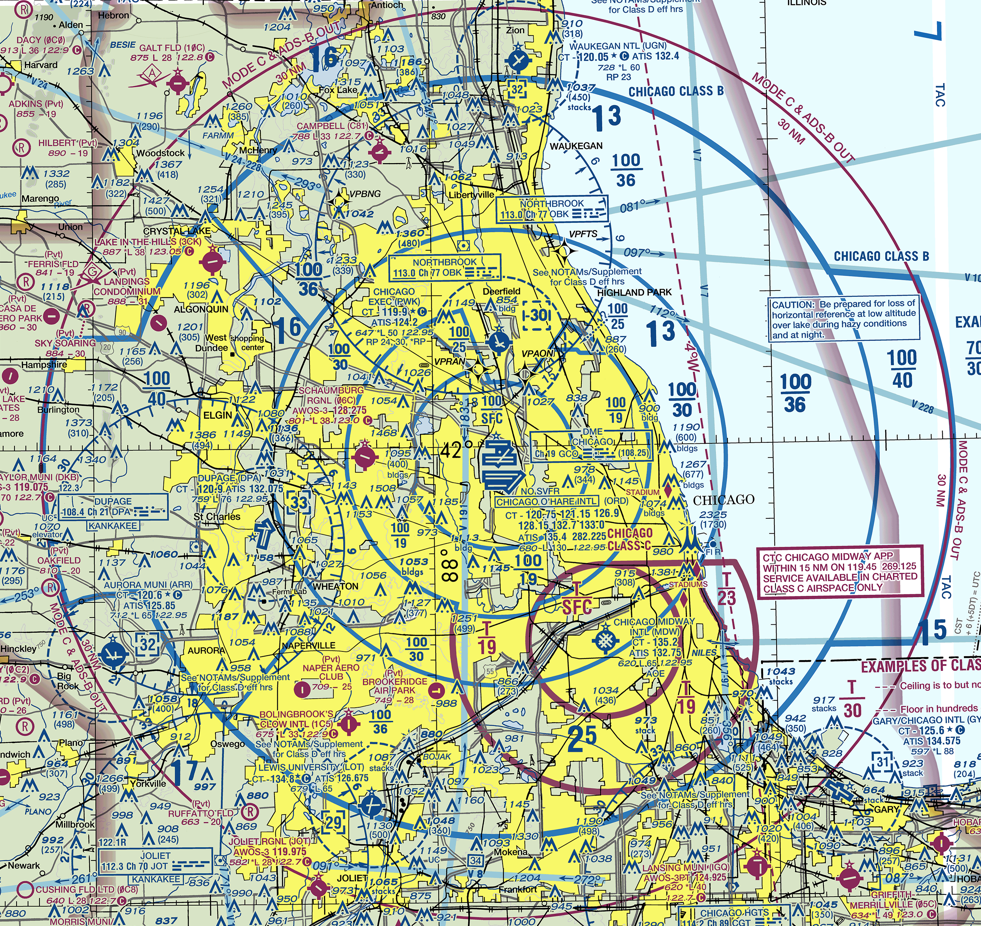
Hello kmeyers. Here is a clip of the Chicago Sectional Chart. Each tick mark of latitude equals one nautical mile, which is 1.15 statute miles. You can see "Chicago Class B" printed over the outer blue circle over Lake Michigan. There is a "donut ring" denoted by blue circles for an area encircling O'Hare that also runs between DuPage airport and Schaumburg airport. This is about 15 miles from O'Hare, so you are probably somewhere within this ring area. You will see a set of numbers "100/30" printed within this ring. This is the top and bottom of Class B shown in hundreds of feet above mean sea level (MSL). This means the base of Class B airspace starts at 3000 feet MSL and the top of Class B air space is at 10,000 feet MSL. Since DuPage has an elevation of 759 feet above sea level and Schaumburg is at 801 feet MSL, the average ground elevation in this area of the ring would be around 780 feet which would mean the base of Class B would start at about 2220 feet above the ground in this area. The dashed blue circle around DuPage depicts Class D airspace which starts at the ground and tops at 3300 feet MSL. The ring that includes Schaumburg airport shows 100/19 which means the Class B base starts at 1900 feet MSL and tops out at 10,000 feet MSL. There is a magenta shaded line running up Lake Michigan, across the top of the picture and down the left side of the picture and under the Chicago area outside the picture (essentially encircling the entire Chicago area). Everything inside this magenta shaded outline has Class E airspace starting at 700 feet above the surface instead of 1200 feet.. This means there is no Class G airspace between 700 and 1200 feet in this area. Class E airspace starts at 700 feet above the surface and goes up to the base of Class B airspace, except for some areas of Class C around Midway and Class D airspace around DuPage and Chicago Executive airports and the class B airspace immediately around O'Hare which starts at the surface for the ring around O'Hare (depicted by 100/SFC), within which there is no Class G or Class E airspace.
Last edited by LLRCFlyer; 04-21-2025 at 12:49 PM.


