


Post pic of your runway from Google Earth
 11-09-2009 | 08:16 PM
#1
Thread Starter
Senior Member
My Feedback: (17)
Joined: Feb 2008
Posts: 983
Likes: 0
Received 0 Likes
on
0 Posts
From: Ewa,
HI
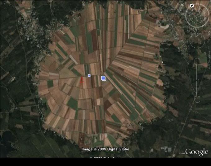
I thought it would be cool to see pics of your runways from Google Earth. Just state where its located and post pic and any background info. I fly at a Super Sod field in Lakeland Georgia, its not an official club, just a bunch of RC pilots who meet up an fly. Its awesome to fly here because the whole field is potentially the runway, so if you run into trouble like a deadstick or something u dont have to worry about making it back to the runway, just put her down anywhere on the field. Circled in red is the pit area, we usually take off parallel to that dirt road in the pic.
Also if anyone is unsure on how we got these pics heres a quick tutorial:
1) [link=http://lmgtfy.com/?q=google+map]Click Here[/link] and go to top search result
2) on the top right of map u can change view to satellite view then find your field using search bar
3)adjust your browser view so the google map pics takes up most of your computer screen
3) use the Print Screen key (usually towards the top right of keyboard, mine actually says Prt Scrn)
4) after you click Print Screen open microsoft paint and press "Ctrl" and key "V" at the same time to paste pic into Paint.
5) save this file as a jpeg and post onto RCU
(Optional Step) you can also open the Jpeg file in a picture editing program to crop the pic and resave.(I wasnt sure how to crop with the Paint program)
 11-09-2009 | 08:21 PM
#2


My Feedback: (1)
This is our Strawberry Field, mile marker 45 on the Black Horse Pike in Atlantic County, NJ. It's about 3500 feet long by about 600 feet wide. It is a full-scale grass runway used by the NJ Forestry for their air-tankers.
CGr.
CGr.
11-09-2009 | 08:26 PM
#3
Thread Starter
Senior Member
My Feedback: (17)
Joined: Feb 2008
Posts: 983
Likes: 0
Received 0 Likes
on
0 Posts
From: Ewa,
HI
Cool CG, it was actually your post on another thread with that same pic that gave me the idea to start this thread. Im not sure if anyone else does this, but sometimes Im a virtual traveler on Google Earth. So keep the pics coming.
11-09-2009 | 08:31 PM
#4


My Feedback: (1)
We'll here's my flying club & other areas in Calgary, Alberta Canada. I can see my vehicle in the club satellite shot! lol
1. CRAMS Flying Field (In Calgary) - We have a fully enclosed club house, picnic tables, 14+ starting stations and setup tables, 2 runways w/ one partially paved, 10 flying stations.
2. 3 Soccer/Football fields when I need a quick fix (In Calgary)
3. My family's Farm - full size runway for our Cessna 177RG (1/2 mile long) where I fly rc w/ my brother when at home. (Near Lethbridge)
Nomination for thread sticky!!!

 11-09-2009 | 08:49 PM
#6
Senior Member
Joined: Aug 2009
Posts: 133
Likes: 0
Received 0 Likes
on
0 Posts
From: Kutztown,
PA
this is out flying field, an old airport, its now used by a lifeflight and civil avation patrol, we use the grass runway for flying, the black square is pit and picnic area 
11-09-2009 | 09:23 PM
#7
Joined: Apr 2006
Posts: 2,275
Likes: 0
Received 0 Likes
on
0 Posts
From: Warialda NSW, AUSTRALIA
G'day All,
This is our field, in Wingham NSW, Australia.
It's an old race track, around the edge, & we share it with the cricket club, 300 yards long, & smooth grass, great place to fly.
Come & visit us any Sunday or Wednesday.
This is our field, in Wingham NSW, Australia.
It's an old race track, around the edge, & we share it with the cricket club, 300 yards long, & smooth grass, great place to fly.
Come & visit us any Sunday or Wednesday.
11-09-2009 | 09:41 PM
#8

What a great idea for a thread! Kudos to you beachbrada, one hell of an idea.
My club field is an old dump that was covered. Our club prez had the field named after him and they opened it in 2001 sometime. I joined late in 2008 so am a relative newcomer to the field. It is located SouthEast of Seattle and is out in the boonies a bit. The flying field itself is located at the top of the mound (about 60ft elevation) above the road that passes by it. Once you are in the air you are actually quite a ways above the trees surrounding it. Grass runway and is a haven for the elk in the winter months for a decent place to bed down and make deep prints in the runway............. Makes landings with smaller tires a bit of a challenge but it still is a very out of the way place and quite nice to get away from it all and tear up the skys.
__________________________________________________ ___________________________________
Of all the things I ever lost....................................... I miss my mind the most!
 11-09-2009 | 10:13 PM
#10

I used to belong to the Screaming Eagles in Plainfield, Indiana. Their field is located on the West edge of Plainfield, off of US 40 at 39 deg. 41.392 min. North latitude x 86 deg. 24.356 min. West longitude.</p>
The Screaming Eagles R/C Club's Field consists of the following:</p>
- 350' X 24' Asphalt Runway
- 500' X 36' Cut Grass Runway (next to Asphalt)
- 180' Asphalt Pits
- 100' Grass Pits
- 2 Asphalt taxiways
- 3 Cut Grass Taxiways
- 60' Control Line Circle
- Shelter House with plenty of picnic tables
- Frequency Board
- Trash Bin
- Port 'O John
The asphalt makes the site a very nice area to fly all year and in any weather.
</p>
11-09-2009 | 10:17 PM
#11
Senior Member
Our field is along the Pacific coast hwy, CA Hwy 1 between San Luis Obispo and Morro Bay. It is on the Choro Creek Ranch, a Cal Poly ranch. Our club built the field for the Cal Poly AeroSpace college, and the field is theirs, but we maintain it and get to use it when they are not flying. We have some very interesting class projects that show up at the field. One of the latese is a large helicopter that was donated to the college. The rotor head stand about 5t above the ground when the skids are on the runway. Oct 31 was the Aero 101 day where 30 teams of four students er team designed and built foam gliders. The earned points, the number of pennys x the seconds in the air. The were High Start launched and an Alumini who has been a club member since his teens and now owns and nitch aero space comany is the main pilot. I've got a bit more photo shop work and sorting before I get this years photos on our web site.
Anyway. Take a look at our home page, WWW.Sloflyers.com. I have a sat shot of our field next to the rapid fire weather infor from Cuesta College which is about a quarter mile away from the field.
Don
Anyway. Take a look at our home page, WWW.Sloflyers.com. I have a sat shot of our field next to the rapid fire weather infor from Cuesta College which is about a quarter mile away from the field.
Don
 11-10-2009 | 08:33 AM
#13

Senior Member
My Feedback: (9)
Joined: Jul 2009
Posts: 395
Likes: 0
Received 0 Likes
on
0 Posts
From: Mount Laurel,
NJ
Pine Baron's RC Field, located in Lumberton, NJ on Stacy Haines Rd, across the street from South Jersey Regional Airport. Runway is 600' by 110'. Park Flyer/Helicopter flyingarea located north of parking area.
11-10-2009 | 09:21 AM
#14
Senior Member
Joined: May 2008
Posts: 828
Likes: 0
Received 0 Likes
on
0 Posts
From: bellingham,
MA
Millis Model Aircraft Club in Massachusetts... Our runway is in the center of the photo. Surrounded by trees with the charles river wrapping around it. I wish we had more open space to fly in. Those trees have a habit of jumping out in front of the planes...
I havent been in the river but others have.
Pop
I havent been in the river but others have.
Pop
11-10-2009 | 10:04 PM
#15

Senior Member
Joined: Mar 2008
Posts: 162
Likes: 0
Received 0 Likes
on
0 Posts
From: san jose,
CA
Morgan Hill Ca.
very nice club. check out their web site. they have a web cam, very cool.
http://www.sccmas.org/
web cams are found after you click (the field>)
very nice club. check out their web site. they have a web cam, very cool.
http://www.sccmas.org/
web cams are found after you click (the field>)

 11-11-2009 | 01:24 AM
#17
My Feedback: (5)
Joined: Sep 2003
Posts: 173
Likes: 0
Received 0 Likes
on
0 Posts
From: Santa Rosa, CA
And here's the field of the Wine Country Flyers in Healdsburg, Calif. Picture taken from a small plane on a fly over. We are in the middle of a vineyard, and this picture was taken in early Spring just before the vines started to green up again.
John
John
11-11-2009 | 01:40 PM
#18
Senior Member
Joined: Oct 2004
Posts: 365
Likes: 0
Received 0 Likes
on
0 Posts
From: Sundom, FINLAND
Does anybody else fly at an ancient meteorite impact site? We do. It's about three miles across, consisting entirely of fertile farm land. Hardly a tree in sight. The impact site is said to be 520 million years old and is situated on the west coast of Finland.
11-11-2009 | 03:18 PM
#20
Joined: Jun 2007
Posts: 536
Likes: 0
Received 0 Likes
on
0 Posts
From: Grand Blanc,
MI
This is where I fly. The club is the Pontiac Miniature Aircraft Club. We are located on the north edge of the Pontiac Lake Recreation Area (one of the Michigan State Parks). I'm not sure how old the sat photo is, but many of the trees at each end of the runway have been trimmed or removed (with the state DNR's blessing, of course)
I liked the field with the webcams. I live about 25 minutes from the field, it would be nice to be able to check the conditions before I leave the house.
This is the club website. http://www.pmac.jydata.com/
Great thread!
I liked the field with the webcams. I live about 25 minutes from the field, it would be nice to be able to check the conditions before I leave the house.
This is the club website. http://www.pmac.jydata.com/
Great thread!
11-11-2009 | 04:26 PM
#21
Senior Member
Joined: Aug 2006
Posts: 562
Likes: 0
Received 0 Likes
on
0 Posts
From: Fort Lauderdale,
FL
[color=#FF0099]Gentlemen,
I fly at Markham Park (Broward County Regional Park in western Ft Lauderdale) KMPF!!!!!!!!!
We have a huge pit area, a jet corner, engine run-up table, 5 pilot cages, 2 taxiways, an impound with electricity and water. A very large pavillion (FBO) with mens and ladies restrooms, picnic tables and four locations of electrical outlets under it. Plenty of parking, a 55 acre airfield, a helicopter field w/2 helipads, a control line field, and the piece-de-resistance.... a 50 x 765 ft asphalt runway located at the turning basin of base to final approach for KFLL (Ft Lauderdale Int'l Airport) so we can watch all the big birds as they throttle back as they make that final turn heading in!!!!! You can't ask for any better than this gentlemen!!!! (and only 10 minutes from our closest local hobby shop or from Sawgrass Mills Mall.....Saks, Neimans, Coach...I'm in love!!!!! )
)
Here is our airfield as it is now.
Our park after Hurricane Wilma (it's the entire NW section of the picture ...I-75/sawgrass runs sortof North/South and I-595/alligator alley runs East/West. Our airfield is extreme SE corner of the park...we back up to both expressways.
and here is the grid from the TFR NOTAM we were sent a few weeks ago grounding all aircraft of any type except commercial within a 30 mile radius for 12 hours due to the Presidents arrival. Our Park/airfield is just above the "P" in the word Plantation.
Our Park also has camping sites for RV's, tennis courts, a fabulous rifle and skeet range, pool, jet ski lake and boat ramps...all bordering on the Everglades National Forest!!!!
Come on down and fly with us anytime!!!!! [8D]
Bev
I fly at Markham Park (Broward County Regional Park in western Ft Lauderdale) KMPF!!!!!!!!!
We have a huge pit area, a jet corner, engine run-up table, 5 pilot cages, 2 taxiways, an impound with electricity and water. A very large pavillion (FBO) with mens and ladies restrooms, picnic tables and four locations of electrical outlets under it. Plenty of parking, a 55 acre airfield, a helicopter field w/2 helipads, a control line field, and the piece-de-resistance.... a 50 x 765 ft asphalt runway located at the turning basin of base to final approach for KFLL (Ft Lauderdale Int'l Airport) so we can watch all the big birds as they throttle back as they make that final turn heading in!!!!! You can't ask for any better than this gentlemen!!!! (and only 10 minutes from our closest local hobby shop or from Sawgrass Mills Mall.....Saks, Neimans, Coach...I'm in love!!!!!
)Here is our airfield as it is now.
Our park after Hurricane Wilma (it's the entire NW section of the picture ...I-75/sawgrass runs sortof North/South and I-595/alligator alley runs East/West. Our airfield is extreme SE corner of the park...we back up to both expressways.
and here is the grid from the TFR NOTAM we were sent a few weeks ago grounding all aircraft of any type except commercial within a 30 mile radius for 12 hours due to the Presidents arrival. Our Park/airfield is just above the "P" in the word Plantation.
Our Park also has camping sites for RV's, tennis courts, a fabulous rifle and skeet range, pool, jet ski lake and boat ramps...all bordering on the Everglades National Forest!!!!
Come on down and fly with us anytime!!!!! [8D]
Bev
11-12-2009 | 11:11 AM
#22
Senior Member
My Feedback: (1)
Here is our field (Georgia Model Aviators). We have:
1. 400x40 asphalt runway.
2. Same size grass runway parallel to asphalt runway.
3. Club house with cover pit areas extending out both sides of the club house.
4. The covered pit area contains about 30 work tables with electric outlets.
5. Weather station which shows current temperature, wind, wind direction, etc. and can be accessed from you home computer.
6. Helio and park plane flying areas off each end of the pit area.
7. Web cams which cover the flying area, each pit area, and the inside of the club house.
8. Five fenced, paved flying stations.
9. Two Porta Potties.
10. Vending machines.
We currently have 250 members. In September we hosted War Birds over Georgia with more than 2000 visitors and 100 pilots. In October we hosted the Southeast HuckFest.
The land is in a flood zone and was just bought by the county for recreation purposes. The are honoring our current lease and it looks like we will be able to get a new, long term lease when the current one expires.
Our we site is: http://www.gmarc.com/Default2.asp
Bruce
1. 400x40 asphalt runway.
2. Same size grass runway parallel to asphalt runway.
3. Club house with cover pit areas extending out both sides of the club house.
4. The covered pit area contains about 30 work tables with electric outlets.
5. Weather station which shows current temperature, wind, wind direction, etc. and can be accessed from you home computer.
6. Helio and park plane flying areas off each end of the pit area.
7. Web cams which cover the flying area, each pit area, and the inside of the club house.
8. Five fenced, paved flying stations.
9. Two Porta Potties.
10. Vending machines.
We currently have 250 members. In September we hosted War Birds over Georgia with more than 2000 visitors and 100 pilots. In October we hosted the Southeast HuckFest.
The land is in a flood zone and was just bought by the county for recreation purposes. The are honoring our current lease and it looks like we will be able to get a new, long term lease when the current one expires
.Our we site is: http://www.gmarc.com/Default2.asp
Bruce
11-13-2009 | 02:58 PM
#24

Our club's field is made up of 3 separate fields. The East field is concrete, the center field (CL) is earth, and the west field is "improved" earth with heli-pads. There's also a off-road course adjacent to the west field.
pic 1 - overview
pic 2 - east field
pic 3 - CLfield
pic 4 - west field
We also have a weather station adjacent to the west field. It's accessable thru our club's website www.arvadamodelers.com/
pic 1 - overview
pic 2 - east field
pic 3 - CLfield
pic 4 - west field
We also have a weather station adjacent to the west field. It's accessable thru our club's website www.arvadamodelers.com/
11-13-2009 | 03:19 PM
#25

Senior Member
My Feedback: (17)
Joined: Jun 2002
Posts: 207
Likes: 0
Received 0 Likes
on
0 Posts
From: Palm Coast,
FL
This is Gateway RC located in Jacksonville Florida. It sits on a 580 acre site, that was recently sold to the VA for a new national cemetery. We have about 3 to 5 years left there before they will need the land we are on. 450ft paved runway, covered pavilion modern rest room facilities, kitchen and office. Home of FX3D-III this coming February, Wednesday the 24th thru Sunday the 28th 2010.


